


MT. UNION WD 01, Huntingdon County, Pennsylvania
About
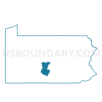
Outline

Summary
| Unique Area Identifier | 659932 |
| Name | MT. UNION WD 01 |
| County | Huntingdon County |
| State | Pennsylvania |
| Area (square miles) | 0.65 |
| Land Area (square miles) | 0.57 |
| Water Area (square miles) | 0.08 |
| % of Land Area | 88.17 |
| % of Water Area | 11.83 |
| Latitude of the Internal Point | 40.38666650 |
| Longtitude of the Internal Point | -77.87547960 |
Maps


Graphs
Select a template below for downloading or customizing gragh for MT. UNION WD 01, Huntingdon County, Pennsylvania


Neighbors
Neighoring Voting District (by Name) Neighboring Voting District on the Map
- BRADY TWP Voting District, Huntingdon County, PA
- MT. UNION WD 02, Huntingdon County, PA
- MT. UNION WD 03, Huntingdon County, PA
- SHIRLEY TWP DIST MT. UNION, Huntingdon County, PA
- WAYNE TWP Voting District, Mifflin County, PA
Top 10 Neighboring County Subdivision (by Population) Neighboring County Subdivision on the Map
- Wayne township, Mifflin County, PA (2,550)
- Shirley township, Huntingdon County, PA (2,524)
- Mount Union borough, Huntingdon County, PA (2,447)
- Brady township, Huntingdon County, PA (1,172)
Top 10 Neighboring Place (by Population) Neighboring Place on the Map
Top 10 Neighboring Unified School District (by Population) Neighboring Unified School District on the Map
Top 10 Neighboring State Legislative District Lower Chamber (by Population) Neighboring State Legislative District Lower Chamber on the Map
Top 10 Neighboring State Legislative District Upper Chamber (by Population) Neighboring State Legislative District Upper Chamber on the Map
Top 10 Neighboring 111th Congressional District (by Population) Neighboring 111th Congressional District on the Map
Top 10 Neighboring Census Tract (by Population) Neighboring Census Tract on the Map
- Census Tract 9505, Huntingdon County, PA (3,510)
- Census Tract 9604, Mifflin County, PA (3,075)
- Census Tract 9510, Huntingdon County, PA (2,674)
- Census Tract 9509, Huntingdon County, PA (2,447)